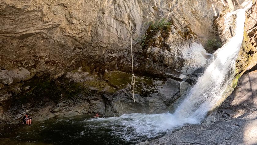
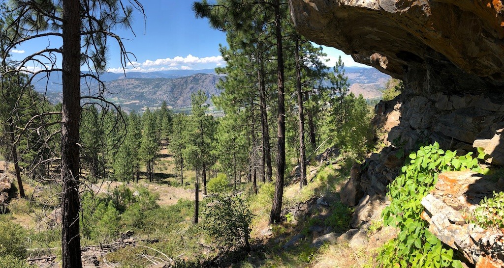
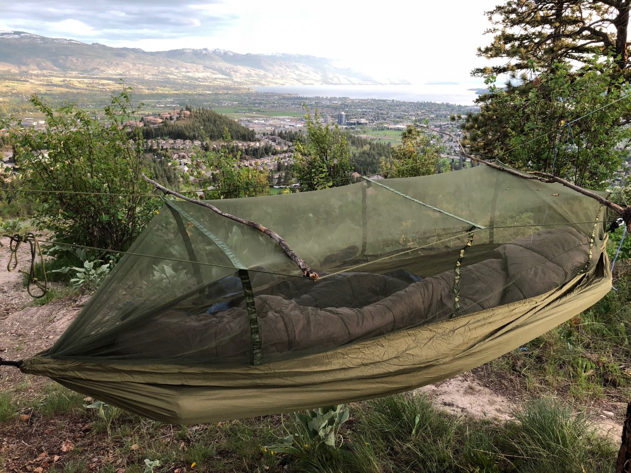
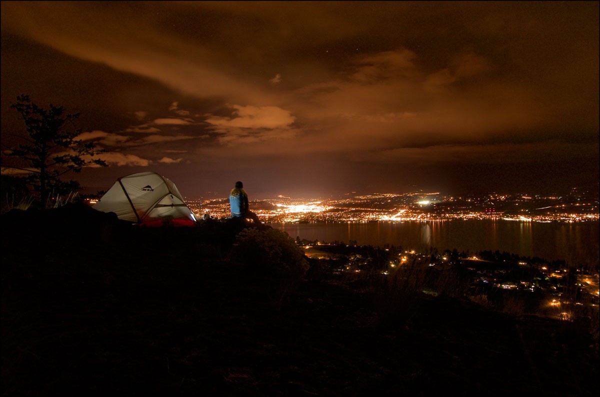
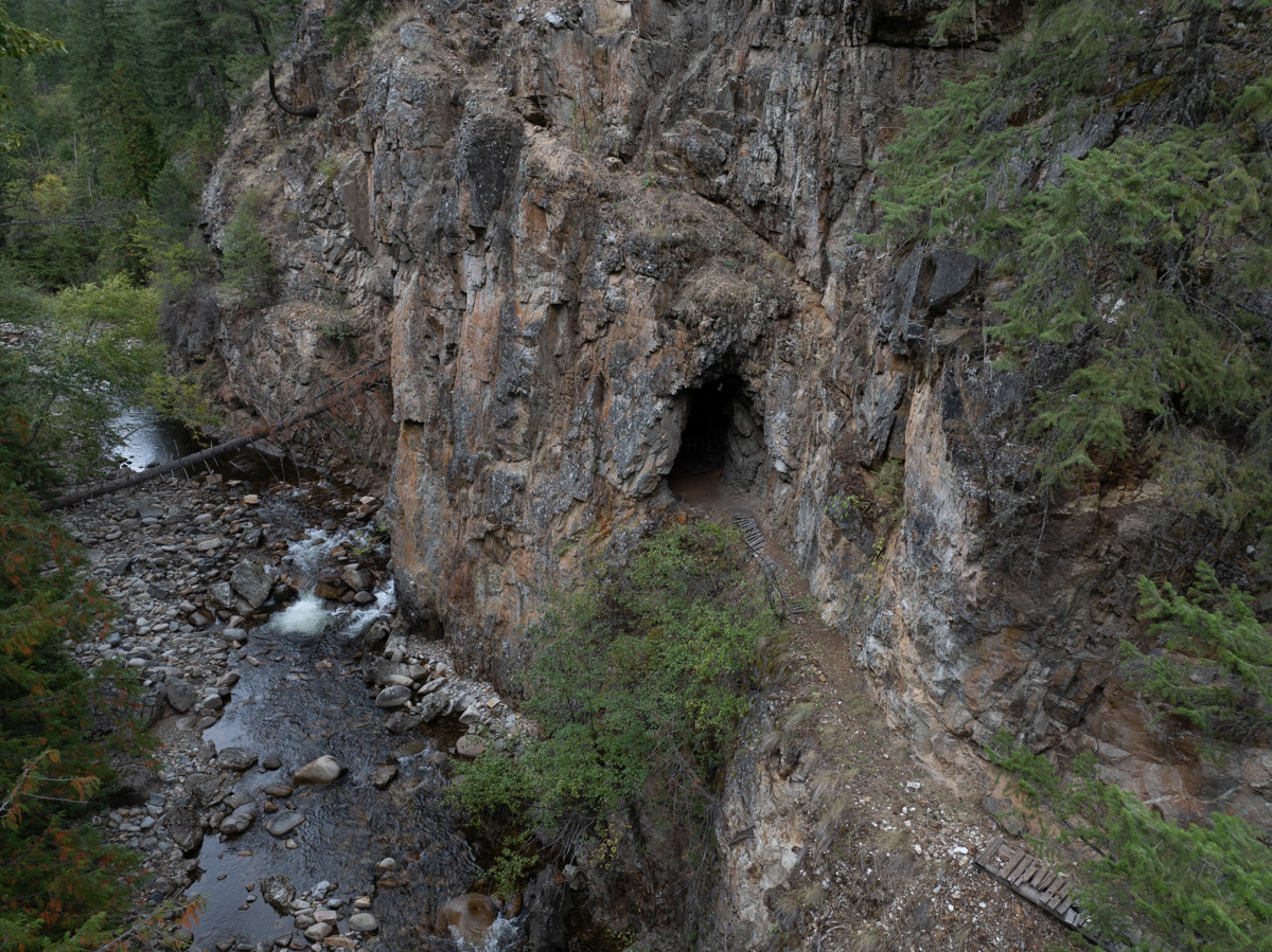
MAY
24

Renata Rock Arch and the return trip

20210522-DJI_0050 The Renata Rock Arch

I stumbled across Renata Rock Arch last year sometime. Likely on Google Earth. The arch is actually a bridge as it was formed by erosion caused by the creek which runs under it whereas an arch is caused by 'erosion inherent in the rock'. It's apparently the largest in Canada at 44m wide, 4m thick, and 20m high.

The Arch resides on the west side of Lower Arrow Lake across from the tiny community of Deer Park. 4km north of the arch is Renata which was a community that was founded by three french prospectors in 1887 and then grew as a result of the CPR railway which is 6 miles away and now called the Trans Canada Trail. A quick google of Renata reveals a very interesting history that may intrigue you. Do it. To touch on that briefly the Columbia River Treaty was ratified in 1964 and the Arrow Dam flooded the region essentailly drowning out many of the communities on it's shores. Speaking with locals of the area we learned that three unwelcoming people now reside in Renata. An amusing story of one shooting the other in the leg over a property line dispute was shared. But I'm getting side tracked...

The Rock Arch is 341km from Kelowna with an additional 2 km to cross the beautiful Lower Arrow lake by boat. The lake is notorious for strong winds that can arise suddenly so I was trying to devise a back-up plan in case we encountrered wind that made canoe travel with lots of camera gear too risky. Jumping back to Google Earth revealed several logging roads that came close as well as the Trans Canada Trail that might make biking an option. I learned on the beach of Deer Park, the canoe take off point, that the houses in the area do have difficult road access but these properties all sport locked gates so accessing the arch by water is likely the best option.

Continue reading
NOV
22

Dead Drives & Sneaky Tricks

2018-11-22-at-20-29-57 Disappearing Data Due to Dead Drives

As I've discussed in other posts I gobble through a whack of hard drive storage shooting video, timelapses and the processing of this imagery behind the scenes. I think I'm just shy of 100 TeraBytes. The other day I had a hard drive die on me which isn't that uncommon. Fortunately I have a back up of all my drives which has been standard practice for years. When I buy a new storage device I always buy two. I pop over to our fire proof safe (which likley wouldn't keep the drives safe from heat in a fire but hopefully dry) and retrieve my back up drive. Plug it in and... nothing.


Now that's a drag. There are several things you can do in the event of a dead drive. Send it off at great expense and have the pro's try to retrieve your data. Try a different power source, cable, and computer port. Or throw your drive in the freezer.

Continue reading
SEP
30

Back to the Future - Drought Mountain

2018-09-29-at-18-00-23 Sneaky place for a pond on Drought Mountain

On April 27th I popped down to Vancouver Island to shoot a FortisBC + BC Ferries LNG bunkering. Here's a photo of the bridge of a BC Ferries vessel which is totally irrevelevant to this blog post but cool.

The bridge has a mirror image with red LED's on the other side - depending which direction it is sailing. Very Star Trekish. 

Continue reading
SEP
18

Twin Lakes

2018-09-18-at-14-27-32 Ice cold colours of the lower Twin Lake

The Monashee's are a gem that remain pristine considering their proximinty to the Okanagan Valley. I know of 6 appealing hikes  based around Cherryville that are between 2-3 hours from Kelowna. There are more than that but some don't interest me as they are of similar distance without the reward of a sexy summit, alpine lake, or spectacular view.

Twin Lakes is the easiest of all these hikes and I think this is my fifth trip to this location. Some of the photos were pulled from other trips as the weather was better.

It's about 2:15 from Kelowna and a one way hike of 1:45. A logging road that requires a bit of clearance but not a four wheel drive takes you up to 1790m. The trail starts with a long up-hill which is always a bit of a grunt when you're not warmed up. Alongside the trail are lots of blueberries which make for satisfying rest stops. If you're fit you could likely do this whole trail without taking a break at all.

Continue reading
SEP
08

Revelstoke National Park

2018-09-08-at-12-21-05 Jade Lake in Revelstoke National Park

I broke some new ground this past weekend in Revelstoke. I was invited to join some friends and their family on an alpine hike in Revelstoke Provincial Park.

This was quite different than most of my hikes in several ways. First off was the 26km paved road that gets you pretty much into the subalpine. We were on the trail head from the parking lot at 9:50am with several tour vans ahead of us. By on the trail head I mean walking the 1km paved road from the parking lot that is closed to all but the shuttle busses. As this was a day trip our packs were light and pace was fast.

We weren't entirely sure of our destination as the fitness level of the group was undetermined. After 90 minutes of hiking well worn, fat trails we came to the Miller Lake fork in the trail (the brochure labels this as a 2-3 hike). It's apparently a 10 minute hike to the lake but we opted to pass it and head for the furthest lake called Jade lake.

Continue reading
SEP
01

Way, way, way, out there.... and beyond....

2018-08-31-at-16-22-01

September long took myself and a buddy on a huge backroad expedition around Adams Lake and Shuswap Lake. I feel I got some stellar images and was able to tick off three bucketlist locations that have been nagging at me. You'll need to click the continue reading button to see the pics in this post and the video at the end.

It started with a rendezvous with a friend at Scotch Creek in a non-descript white van. He suggested hitting up Johnson Lake which I'd never heard of but is 65km north east of Kamloops or a massive potato gun shot east of Barrier. After some horrific premade hamburgers we plummeted into his sloppy ruddered kayak and wiggled around crystal blue waters. Upon our return, truckloads of humans began to arrive at the forest service rec site marking the start of the long weekend so we moved on.

Johnson Lake and Adams Lake
Suspicious rubber boots in the fire pit.

We drove north up Adams Lake to the head of the lake where we turned east and started the stunning drive passed Momich Lakes Provincial Park and a huge black bear.

Continue reading
AUG
06

Alpine wandering


Happy BC Day!

Had my first trip into the alpine this weekend. 68km east, as the crow flies, of Kelowna is Granby Park. Home to the southern interiors largest pristine watershed. The Granby Range makes up the southern most mountains of the Monashees and is prime grizzly territory. The peaks aren't as gnarly as you'll find between highway six and Revelstoke but the forests are beautiful and the alpine offers grand views.  

Logging on the outskirts of the park makes for easy access. You can drive to 5600' at which point you come to a 'No motorized vehicles from June - October' sign. A hike up a gentle slope will get you to the summit in about 1:45.We passed a band of wild flowers between 6000' and 7000' feet and saw some humongous deer. Probably the largets I've ever seen. The park also has mountain goats, lynx, cougar, bobcat, wolverine and martin. None of which we saw as we were making a racket to ward off bears.

Continue reading
JUL
22

Way up the creek

South Okanagan Exploring

Had an interesting adventure this weekend. Myself and a friend ventured up onto the Okanagan Highlands above Okanagan Falls. The 201 forest service road was immaculately groomed. Unfortunately this didn't make a difference for some cherry picker workers from Keremeos who were hitch hiking do to low fuel levels while on route to a back country rave at Clarke Lake. Being the kind Canadians we were, we picked them up and delivered them to their destination. Then ventured on to Allendale lake which is totaly new territory to me. It's a man made lake with 6 forest service rec sites. 

We opted to venture a bit further and try to find a spot with less humans. This took us to Solco Lake. High in elevation and off the beaten track. We managed to find ourselves a sweet campsite that was isolated from the other inhabitants of the lake. Had a moose escort on route too which was a bonus. The first 90 seconds of the video at the end of this post is some eye candy of the lake. It got very cold at night and made for some cool mist in the morning. 

On our return into the valley we stopped for a few valley views and stumbled across a petrified log. 

Continue reading
JUL
06

Miserable Mission

2018-07-04-at-08-19-22-Small

In the summer of 2013 I hiked into Divide Lake in Okanagan Mountain Park on a cell tower access road. Divide is a  narrow lake near the summit that's wedged between two large rocks that resulted from some unpleasant tectonic rumblings. We spent the night at Divide lake and then dropped down the western slopes for 90 minutes to Baker Lake. It's the largest lake in the 10,000 hectare park and has a delighful little tent spot. It's ridiculously remote and terribly appealing.

Divide Lake

Filthy Divide Cabin

Continue reading
JUL
01

Dangling a Carrot on Canada Day

Finally got up Carrot Mountain in West Kelowna. Most hiking friends of mine have been up there and most seem to agree that it's a grunt.

Compounding the grunt factor was the camera baggage. I was somewhere around 70lbs. Fortunately there is a waterfall about half way up that we were able to fill extra water bottles at so we didn't have to pack all the water all the way. This water source seemed to appear and disappear as we hiked. I suspect it is spring fed but we used the water for cooking and coffee and boiled it. The mosquitos in the valley on the hike up were positivley horrific.

Once up top the southerly views are great over West Kelowna. The wind was absolutely howling so we were forced to camp away from the cliff edge to get some shelter.

Continue reading
MAY
11

City views from McDougall Rim

2013-04-26-McDougall-Rimm-Pano-small

McDougall Rim is the prominent mountain to the west that can be seen from pretty much anywhere in Kelowna. It's gentle slope rises up to 1400m and is home to Hayman Lake which is actually more of a swamp. Below McDougall Rim is Rosevalley Resevoir which is a popluar hiking and biking destination. This is a sweet hike with spectacular views starting just after the 2km mark. It's a well used single track trail that climbs quite conistantly. It's not terribly steep but is long if you go to the top. There's no potible water and it's bear country so be prepared.

Hiking access to McDougall Rim starts off of Bentley Rd. in West Kelowna above Bylands Nursery. After a couple of kilometres of private road you come to an obvious parking lot at the cattleguard. Mutliple atv/4x4 trails head up the hill to your right (north). If you stay right you'll find a well groomed hiking trail that winds its way up but it is much shorter to head straight up and you will eventually bump into the main hiking trail. 


Continue reading
MAY
08

Drone flying above Peachland

2018-05-08-at-15-24-03 Above Antler Beach Drone Okanagan

 My latest piece of video production equipment is a drone which is also known as a UAV (Unmanned Aerial Vehicle) or a UAS (Unmanned Aerial System). To fly a drone commercially requires much more behind-the-scenes than you might think. Especially if it weighs more than a kilogram. You need to have training which includes safety protocals, aviation weather knowledge, knowledge of Transport Canada aviation regulations, Restricted Operators License - Aeronautical for a radio and more. You need a medical form from a doctor, a visual observer to be with you to help maintain security of the operation area and watch for hazards including other aircraft. You need to apply for a Special Flight Operations Certificate (SFOC) from Transport Canada which (at this point in time) requires an application for every commercial flight. These applications take as many as 22 business days to get approved. You must have maintenance procedures in place and documented as well as a current flight log. It's a lot of work but the opportunities and footage that can be obtained are pretty cool. 

 The places I can train and recreationally fly my drone in Kelowna are very limited. Most of Kelowna falls within Class D airspace as seen in the picture above so when learning to fly a drone I needed to venture off into the boonies. The Regional District of The Central Okanagan's Parks and all of the City of Kelowna's and West Kelowna's parks are no fly zones without permission. 

 As of late I've been getting out as much as possible to practice flying and train the visual observers I'll be working with. In the opening shot of the video below I'm using an advanced feature involving waypoints. I can pre-fly the route and set waypoints with camera direction and hazards in mind. Upon completion the controller uploads the waypoints to the drone and it flies the route perfectly smoothly then hovers at the end of the route. Pretty cool.

Continue reading
MAY
04

Dilworth Summit

2018-05-04-at-19-49-2_20180615-002917_1


This was my first venture out with my daughter this year. My daughter, her friend and myself spent the night on top of the peak of Dilworth Mountain. It’s super easy walking access on a windy paved road that climbs steeply up to the radio towers.

 Because my daughter brought her friend I stayed in a hammock nearby which has a built in mosquito net and the kids took the tent. It was the first ever time camping for the young lady accompanying us and she was very excited.

Continue reading
APR
27

First Hike of the Season up Mount Boucherie

2016-09-03-Kelowna-View-from-Boucherie-Mtn-Paul-Cotton-Films-34

I love to be outdoors. Now that ski season has ended I try to get out in the local Okanagan hills as much as possible. This usually involves hiking with far too much gear up one of our local mountains and spending the night.  As often as not I'm by myself which suits me just fine. There's something very peaceful about being away from all the h...

Continue reading