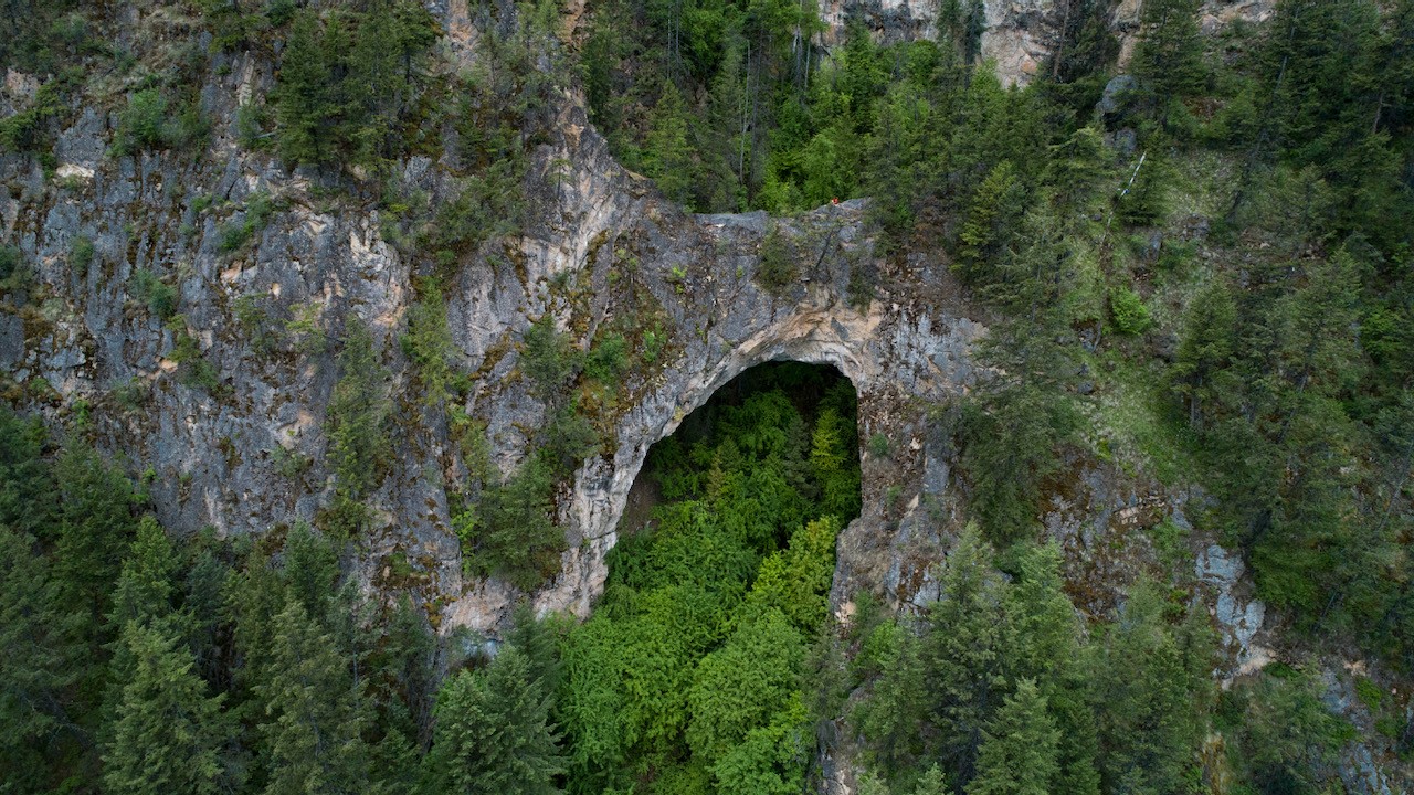
I stumbled across Renata Rock Arch last year sometime. Likely on Google Earth. The arch is actually a bridge as it was formed by erosion caused by the creek which runs under it whereas an arch is caused by 'erosion inherent in the rock'. It's apparently the largest in Canada at 44m wide, 4m thick, and 20m high. The Arch resides on the west side of Lower Arrow Lake across from the tiny community of Deer Park. 4km north of the arch is Renata which was a community that was founded by three french prospectors in 1887 and then grew as a result of the CPR railway which is 6 miles away and now called the Trans Canada Trail. A quick google of Renata reveals a very interesting history that may intrigue you. Do it. To touch on that briefly the Columbia River Treaty was ratified in 1964 and the Arrow...
On April 27th I popped down to Vancouver Island to shoot a FortisBC + BC Ferries LNG bunkering. Here's a photo of the bridge of a BC Ferries vessel which is totally irrevelevant to this blog post but cool. The bridge has a mirror image with red LED's on the other side - depending which direction it is sailing. Very Star Trekish. On the return trip I was rubbernecking the Coquihalla Connector decent down into Okanagan Valley..... always spectacular..... when I happened to see a cave far above in the bluffs on Drought Mtn. I suspect this might just be a boy thing but I'm always intrigued by caves. I should note that this isn't the obvious big cave that's above Highway 97 and below the Connector. Mission spawned. I'd be back in the near future. The following day I plotted a route on Google Earth to Drought Mtn which...
September long took myself and a buddy on a huge backroad expedition around Adams Lake and Shuswap Lake. I feel I got some stellar images and was able to tick off three bucketlist locations that have been nagging at me. You'll need to click the continue reading button to see the pics in this post and the video at the end. It started with a rendezvous with a friend at Scotch Creek in a non-descript white van. He suggested hitting up Johnson Lake which I'd never heard of but is 65km north east of Kamloops or a massive potato gun shot east of Barrier. After some horrific premade hamburgers we plummeted into his sloppy ruddered kayak and wiggled around crystal blue waters. Upon our return, truckloads of humans began to arrive at the forest service rec site marking the start of the long weekend so we moved on. Johnson Lake and...